
While escaping one of Amsterdam’s sudden downpours I ducked into the City Hall building entrance by the Waterlooplein and discovered a dioramic wonder.
The main lobby is rather stark, except for a diorama stretching along one wall that details the water levels in Amsterdam and the city’s underpinnings.
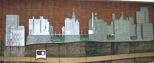
You can see in the diorama the columns sunk into the soft sand under the city’s buildings, the Metro tubes with subways running, and the various levels of water in the city’s canals.
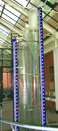
The three columns above represent the level of the North Sea at this moment in IJmuiden, the level of the water at Vlissingen (Flushing), and the level the water reached during Holland’s worst flood in 1953. This was 4.55 meters above the NAP.
The NAP is the NORMAAL AMSTERDAMS PEIL, which translates into the “Amsterdam Ordnance Datum.” This water level was recognized over three centuries ago as the referral point for all constructions in the Netherlands and several adjoining countries.
What does this mean to you? Well if you walk down the spiral staircase around the columns you will pass a bronze knob, which is the actual NAP point. From here you can see how far you are actually under water.
Amsterdam got its name from a dam constructed in the River Amstel which kept water from flooding the town. To allow ships with cargo in and out of town, locks were constructed that would open and close when the water went above a certain level, this level became the NAP.
So my escape from a watery downpour only brought me into a more complete understanding of the complex relationship between Amsterdam and the sea.
The NAP project here in the Amsterdam City Hall was constructed and designed by Louis van Gasteren and Kees van der Veer in 1988.